
Distribution Maps

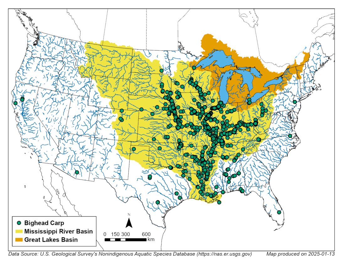
Bighead Carp Distribution

Image
Copyrighted Joseph R. Tomelleri illustration of a bighead carp with silver scales and dark blotches along the back, no scales on the head, low set eyes, downward slanting mouth and a keel that extends partway along belly.
Caption
Bighead carp. © Joseph R. Tomelleri
Image
Map identifying bighead carp in the Mississippi River and Great Lakes basins.
Caption
Historical occurrences of bighead carp in the United States. Data from the U.S. Geological Survey Nonindigenous Aquatic Species database, January 13, 2025, represent reported observations of bighead carp. The historical occurrence map of bighead carp shows the majority of occurrences are in the Missouri River, Ohio River and Mississippi River basins in the central United States. Populations may not be established in all mapped locations.

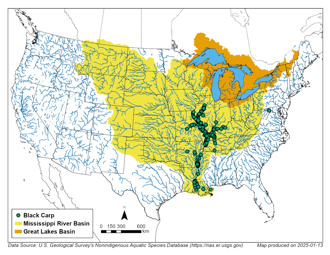
Black Carp Distribution

Image
Copyrighted Joseph R. Tomelleri illustration of a black carp with dark large scales, no scales on the head and a pointy shaped face.
Caption
Black carp. © Joseph R. Tomelleri
Image
Map identifying black carp in the Mississippi River and Great Lakes basins.
Caption
Historical occurrences of black carp in the United States. Data from the U.S. Geological Survey Nonindigenous Aquatic Species database, January 13, 2025, represent reported observations of black carp. The historical occurrence map of black carp shows the majority of occurrences are in the Mississippi River Basin in the central United States. Populations may not be established in all mapped locations.

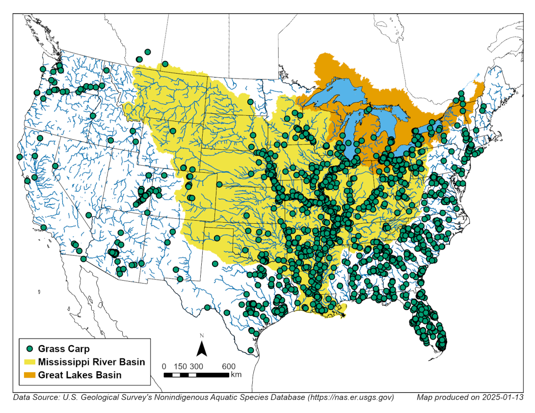
Grass Carp Distribution

Image
Copyrighted Joseph R. Tomelleri illustration of a grass carp with large olive-brown scales, no scales on the head, and eyes centered on a flattened head with an oblong body.
Caption
Grass carp. ©Joseph R. Tomelleri.
Image
Map identifying grass carp in the Mississippi River and Great Lakes basins.
Caption
Historical occurrences of grass carp in the United States. Data from the U.S. Geological Survey Nonindigenous Aquatic Species database, January 13, 2025, represent reported observations of grass carp. The historical occurrence map of grass carp shows the majority of occurrences are located in the central, midwest and eastern United States. Populations may not be established in all mapped locations.

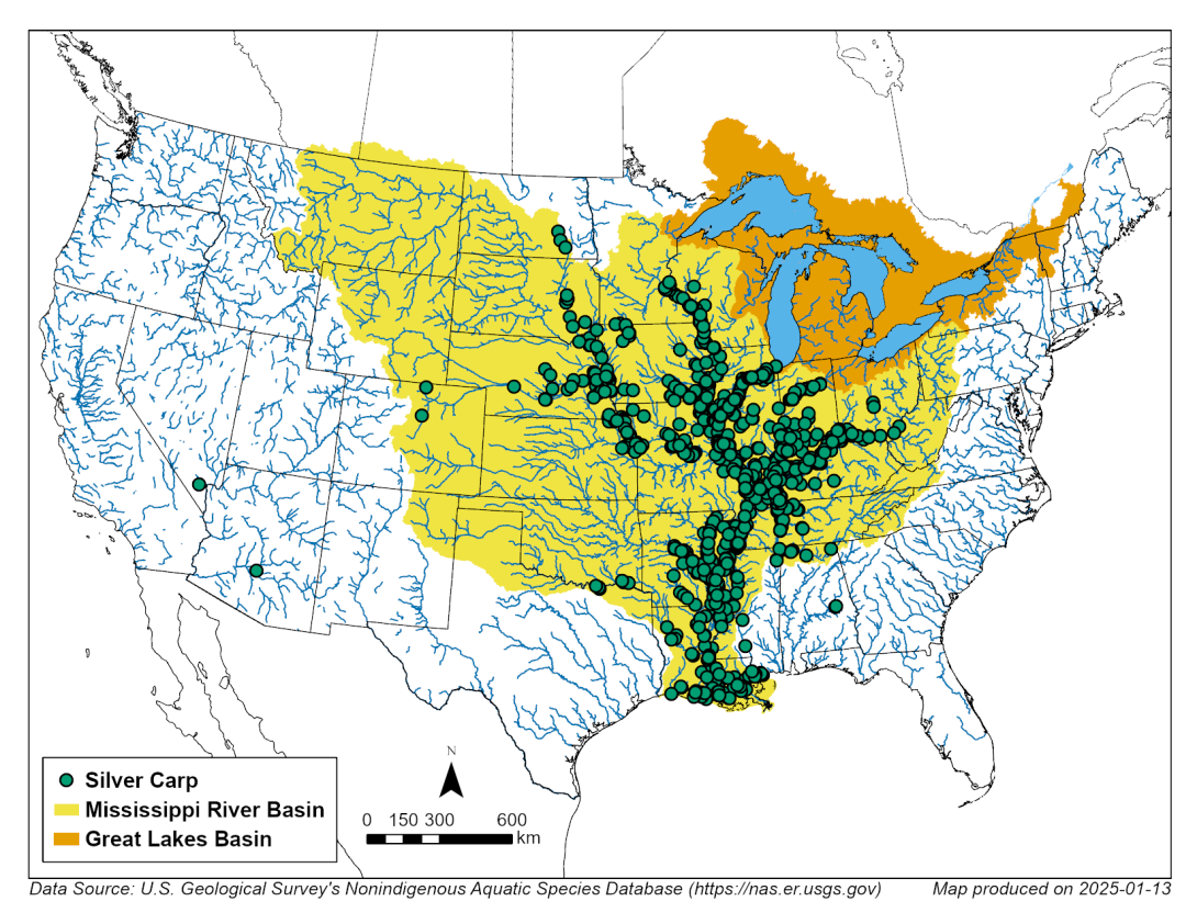
Silver Carp Distribution

Image
Copyrighted Joseph R. Tomelleri illustration of a silver carp with small silver scales, no scales on the head, low set eyes, downward slanting mouth and a keel that extends to the throat.
Caption
Silver carp. © Joseph R. Tomelleri
Image
Map identifying silver carp in the Mississippi River and Great Lakes basins.
Caption
Historical occurrences of silver carp in the United States. Data from the U.S. Geological Survey Nonindigenous Aquatic Species database, January 13, 2025, represent reported observations of silver carp. The historical occurrence map of silver carp shows the majority of occurrences are in the Missouri River, Ohio River and Mississippi River basins in the central United States. Populations may not be established in all mapped locations.
March 2026

Upper Illinois River Status Map

While the Invasive Carp Regional Coordinating Committee’s work spans the Great Lakes basin, the Illinois River’s connection to Lake Michigan within the Chicago area waterway presents the highest risk as a potential pathway for invasive carp to enter the Great Lakes. For this reason, many of our efforts focus on intensive monitoring and operating deterrents in the Chicago area waterway and upper reach, as well as reducing the most abundant populations of invasive carp—specifically silver carp and bighead carp—in the Illinois River. Grass carp are also present and black carp have been captured in the lower river. Over the last 15 years, our projects have succeeded in keeping Illinois River silver and bighead carp populations about 50 miles from Lake Michigan. Five detections above the population front are noted below.

Image
A map displaying the electric barrier system with a star located 37 miles from Lake Michigan in the Chicago Area Waterway in Northeast Illinois. The leading edge of adult bighead and silver carp is 10 miles below the electric barrier system. The leading edge of potential bighead and silver carp reproduction is depicted as 62 miles away from Lake Michigan in the Marseilles Pool. Verified spawning is shown to be in the Starved Rock Pool, 88 miles away from Lake Michigan.
Caption
The Upper Illinois River Invasive Carp Status Map shows the current population front for various life stages of bighead and silver carp. The adult population front is shown in the Dresden Island Pool, 47 miles from Lake Michigan. The map also notes locations for the following detections:

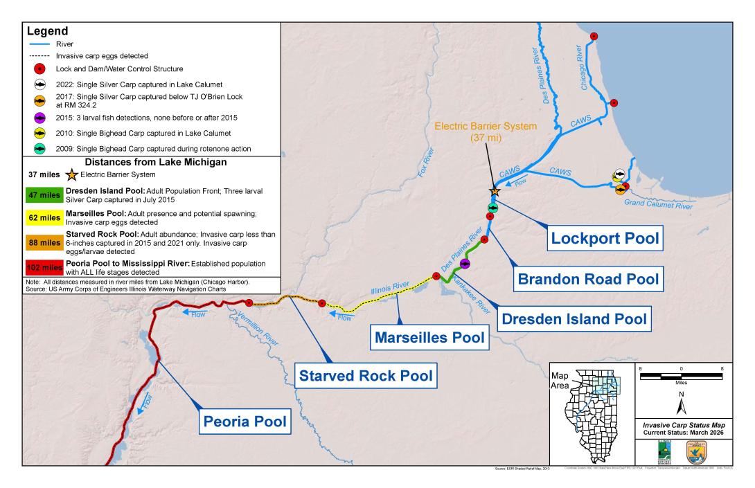
The 2022 capture of a single silver carp in Lake Calumet.
The 2017 capture of a single adult silver carp above the electric dispersal barrier system, but below T.J. O'Brien Lock 9 miles from Lake Michigan.
The 2015 detections of three larval fish in the Dresden Island Pool. There have been no other detections before or after the 2015 event.
The 2010 capture of a single bighead carp in Lake Calumet.
The 2009 capture of a single bighead carp during rotenone action in the Lockport Pool.

All distances measured in river miles from Lake Michigan (Chicago Harbor). Source: U.S. Army Corps of Engineers Illinois Waterway Navigation Charts